Pipeline Integrity for the Natural Gas Industry
 Pipeline failures from small leaks to catastrophic breaks have been around for a long time. To address this issue the federal government passed the Pipeline Safety Improvement Act of 2002.
More recently, a series of major pipeline failures including the fatal tragedies in San Bruno, Calif., and Allentown, Pa., were most likely the impetus for the U.S. Department of Transportation to announce the Pipeline Safety Action Plan in 2011. Congress incorporated many ideas outlined in this plan into the Pipeline Safety, Regulatory Certainty and Job Creation Act, which President Obama signed into law in January 2011.
According to the U.S. Department of Transportation (DOT) Secretary Ray LaHood, the intent of this legislation is to provide the Pipeline and Hazardous Materials Safety Administration (PHMSA) with additional enforcement tools and higher civil penalties for pipeline operators who do not fully comply with the existing safety regulations. In many cases, the new regulations have doubled the maximum fines for safety violations. These new regulations have also greatly expanded the requirement for pipeline operators to develop and maintain integrity management (IM) systems and tasks PHMSA to evaluate current risk-based reassessment interval requirements.
Under the existing Pipeline Safety Improvement Act, pipeline owners and operators were already attempting to gather data to comply with mandatory transmission integrity management plans (TIMP) and distribution integrity management plans (DIMP). These plans require the collection and management of a multitude of data that include discovery and remediation steps for corrosion, manufacturing defects, construction issues, third-party damage and other anomalies.
 Couple all of this activity with the constantly expanding U.S. shale gas discoveries and requirement for future new pipeline infrastructure and you have an immediate need to establish a program of pipeline data acquisition (in x, y and z) and a data management system that is dependable, accurate, secure and accessible to the engineers in the field, as well to the managers and consultants back at their respective corporate or regional offices.
Gas utilities have a strong history of wanting to conduct inspections, to maintain their pipelines and to detect and repair leaks. Most of the large and small gas utilities have implemented some form of sophisticated information management system or enterprise GIS system to record compliance efforts. The truth is that, in many cases utilities have decades of paper files and important data continues to be accumulated every day on spreadsheets and other paper files. It has been difficult if not impossible to aggregate and file all of this paper information and to deliver it in meaningful way to the company’s enterprise system back at the corporate office.
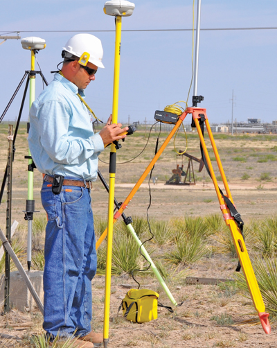
An effective pipeline integrity program requires that data be acquired in the field and coupled with accurate positional information (in x,y and z) to allow the data to be seamlessly managed in the owner’s GIS management system. Technologies exist today to map most underground utilities to tolerances of as low as 4 in. in the x and y location and as well as depth (z). In most cases, these technologies allow immediate upload to cloud-based GIS portals where the information can be viewed, managed and securely shared, with permissions, among the appropriate stakeholders. In addition to underground pipeline positional information, other data such as depth of cover, geo-referenced photos, geo-referenced video (both of the interior of the pipeline and of the ground level features) can be uploaded and viewed via cloud based GIS portals such as GeoUnderground, developed by Geospatial Corp.
Having trained technicians with specialized mapping technologies, digital data capture devices and a mobile GIS portal, pipeline operators can dramatically increase the amount of data captured in the field without adding significantly to workloads. Tying this information to specific co-ordinates and/or weld joints allows for easy retrieval and the fact that the portal is cloud-based allows for secure and simple sharing among stakeholders and/or regulatory officials.
Integrity management is required for both existing and newly constructed pipelines. PHMSA regularly conducts audit of new pipelines looking for documentation on, among other items, the pipeline manufacturer, date and time of manufacture, tensile strength and ladle analysis. In addition, information on any coatings, all types of quality control (QC) certifications, contractor information, welding reports, bending reports, hydrostatic testing reports and survey information.
All of this documentation is also required to substantiate conditions and remediation methods selected for “anomaly excavations” that are required when “in line inspection” (ILI) results indicate that there may be a section of existing pipeline scratched, dented or damaged or corroded. At that time, a utility is required to excavate and determine the exact type of anomaly that exists and determine and execute an approved remediation plan for that specific defect. The same type of detailed forms and information that was required under PHMSA for new pipeline construction is required for anomaly excavations. Tying each weld joint and pipeline segment to an x, y and z co-ordinate and uploading this information to our cloud-based portal at the site on daily basis will prove immensely valuable for future planning, management and compliance situations.
In 20 to 30 years, this information is likely to be extremely valuable to pipeline owners and operators to show that specific policies and procedures were in place at the time of construction or repair procedures. Beyond compliance and possible litigation mitigation, this data will help pipeline operators more cost-effectively manage their transmission and distribution systems.
 No utility wants to be involved in a catastrophe like the San Bruno explosion and it is becoming evident that to prevent such disasters, a comprehensive asset management system needs to be implemented. To ensure pipeline integrity, utilities need to document and review the entire lifecycle of the pipeline and all related maintenance and other work related activities associated to the pipeline. This information needs to be tied to a GIS-centric data management system accessible to all levels of management subject to the appropriate security restrictions.
The risk mitigation and operational benefits of developing such capabilities are significant and pipeline operators should take advantage of available new field data acquisition and cloud based data management technologies to begin to develop information systems based on extremely accurate positional information.
Those utilities that have existing data management and work management enterprise systems in place should evaluate the ability of their current processes and systems infrastructure to meet the rapidly increasing regulatory requirements and to provide the detailed data required to mitigate future risks and liabilities.
Detailed data available in real time to all stakeholders is the key to pipeline integrity which will save lives, provide peace of mind and have a positive effect on a utility’s operational and management spend in the future.
Mark Smith is CEO of Geospatial Corp., an infrastructure technology company that uses various technologies to accurately and economically map underground utilities in 3D and manages positional data, documents, photos and video in a cloud-based GIS portal.