Company Profile: Underground Imaging Technologies
June 1, 2008
 We all know that over the past few decades there have been quantum improvements in technologies we all thought were state-of-the-art when we first learned of them. Yet, many of us still hold on to perceptions of the past that are no longer valid. An example of this would be my prior experiences with ground penetrating radar (GPR). I suspect you could have characterized me as a GPR skeptic because many people and organizations had found their way through our office wanting us to buy or use GPR technology that didn’t live up to what was advertised.
I remember when I recently received a call from an executive recruiter who wanted me to consider a CEO role with Underground Imaging Technologies Inc. (UIT) — a company that was involved with GPR and infrastructure mapping. I was initially skeptical. However, on additional investigation and study, I learned there have been many improvements in imaging underground features and UIT was one of the real leaders in this field.
In my research of GPR-based technology in general, and of UIT specifically, I came to understand how multiple technologies in the form of both hardware and software have been combined to yield incredible results. That is why I am so pleased to have assumed the responsibilities as CEO of UIT — and perhaps starting out as a skeptic was a good thing because I can identify with people who haven’t heard of the exciting new developments.
After being on the job just one week, I attended a meeting along with one of UIT’s strategic allies, Spectra Subsurface Imaging LLC, Latham, N.Y. This meeting was in the home office of a major utility and we were there to review the results of a recently completed project in which approximately 6.5 miles of roadway was scanned to ensure there were no unknown conflicts along the planned installation path of a new 345 KV transmission line.
Imagine hearing your customer say that the project was a complete success and that they couldn’t be more pleased with the outcome. They went on to say that the mapping showed a number of otherwise unknown and conflicting utilities so they would be able to change the alignment prior to putting the contract out to bid and that the savings would be significant. I knew right then that it wouldn’t be long before other major utility owners would learn of this result and understand that they too could benefit greatly by using UIT’s underground mapping services to avoid the potential of utility strikes and/or change orders during construction.
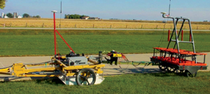
The underground mapping of the 345 KV project was not completed using “ordinary” GPR (single channel). It was completed by employing the powerful components of the UIT system that include GPR in a proprietary multi-antenna array, known as TerraVision, and proprietary software to create a 3D image of the subsurface and find the utilities in the imaged area. The GPR and positioning systems feed data into a data acquisition shell, which co-registers all inputs — including various types of global positioning or laser survey systems, in such a way that allows for construction of a 3D image of the data. The deliverable that UIT provides to its clients is a “vision” of the subsurface infrastructure that is geo-referenced, thereby showing the location of those identified features, including depth, to sub-decimeter levels of accuracy. The end product is a CAD file in 2D or 3D presentation. The deliverable can then be uploaded to any geographic information system, CAD program or design software the owner prefers.
All of the data collected by UIT is post processed and this is done by geophysical analysts employed by UIT. They are experts in completing the detailed analysis of the data gathered, and they are assisted in their work by UIT’s sophisticated software program called SPADE. The geophysical analysts are led by UIT vice president of operations Gary Young, PG, who is also a geophysicist. Dr. Dave Hanson, who splits his time between UIT and Vermeer Corp., and Young have been the technological backbone of UIT through the developmental phase of UIT and they remain critical components to the overall success of UIT today.
One of Young’s favorite sayings is: “You cannot cheat physics.” To this point, he is always the first to say that the technologies amassed by UIT are not always the answer. Since there is no silver bullet, and in order to have the outcome desired, you have to take into consideration the fact that “… some soils are very GPR-friendly but others are not, and these include soils with high clay content or where there is a high saline groundwater table, but our system’s time-domain electromagnetic (TDEM) component isn’t bothered by these constraints. As a result, the equipment utilized by UIT enables us to specifically tailor the system components to the situation, the environment, the soil, and the type and depth of the targets being investigated.”
UIT and its strategic allies have been employed to locate archeological artifacts, storage tanks, buried structures and pipes and conduits of all types. One of the most recent areas of great success for UIT and another strategic ally — TBE Group, Tampa Bay, Fla. — has been confirming interments or site vacancies in cemeteries. Individual and independent cemeteries are being consolidated and expanded by larger cemetery management companies and these operations require accurate mapping of cemeteries, as records are not necessarily up-to-date or correct. The solution to this problem is the application of UIT’s GPR and TDEM systems simultaneously.
Pre-planning and making the investment up front before a project goes out to bid pays for itself many times over. I really cannot think of a better example of this than one that UIT was involved with a few months back. In this case, a New England utility considered using UIT and Spectra to do a mapping survey in advance of having a new transmission line installed. The utility initially decided to forego the expense, hoping the as-builts and field work would be sufficient. After the contractor had a number of hits involving unknown and unmarked utilities — one including a fiber-optic cable that had to be repaired twice — construction was stopped and the mapping of the remaining project was completed by UIT and Spectra. The result was that there were no further incidents or unexpected expenses.
Mark R. Wallbom is CEO of Underground Imaging Technologies Inc.